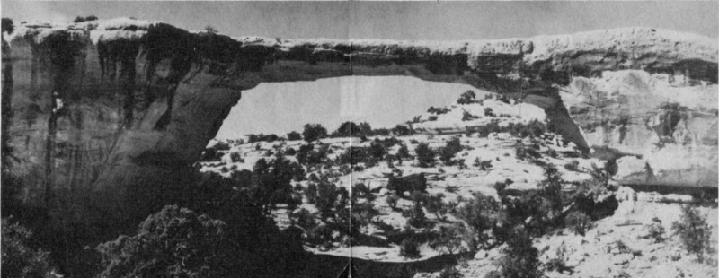
Cover: Owachomo Bridge.

Natural Bridges
NATIONAL MONUMENT · UTAH

UNITED STATES DEPARTMENT OF THE INTERIOR
Douglas McKay, Secretary
NATIONAL PARK SERVICE, Conrad L. Wirth, Director
Three gigantic natural bridges carved out of sandstone and located in a region of superb scenery
San Juan County, in the southeasterncorner of Utah, is a land of brilliantlycolored cliffs, tortuous box canyons, pinnacles,and arches. Near the center of this scenic andgeologic potpourri is Natural Bridges NationalMonument.
Within the monument are three huge naturalbridges. While they are exceeded in size by thegreat Rainbow Bridge, which lies about 60 milesto the southwest in Rainbow Bridge NationalMonument, they rank with the largest knownnatural bridges.
One of these bridges—Owachomo—is directlyacross the 600-foot-deep Armstrong Canyon andspans the mouth of a short tributary canyon.The road from Blanding, Utah, ends at the rimof the Armstrong Canyon. To visit the otherbridges in the monument, one must walk. Thetrail is unimproved, and sometimes rough, butthe 6-mile hike is rewarded by views of themagnificent canyons, the bridges, and ancientIndian ruins.
The headquarters area of the monumentoverlooks the Owachomo Bridge, and a 300-yardtrail drops to the bottom of ArmstrongCanyon to a point where one can walk under thebridge. Continuing on this trail, Sipapu Bridgemay be reached by a 3-mile walk; however, ifyou wish to see all three bridges with the leastwalking, drive your car from headquarters, 4½miles, to the Kachina Bridge parking area andfrom there it is three-quarters of a mile by aladder trail to Kachina Bridge and 2 miles fromKachina to Sipapu Bridge, up White Canyon.No trail is maintained between Kachina Bridgeand Owachomo Bridge.
The Bridges and Their Names
The bridges were first seen by white man in1883 when Cass Hite, a prospector, visited theregion. National publicity was given to the areain 1904 when an illustrated article appeared inthe National Geographic Magazine. In 1908 thearea was proclaimed Natural Bridges NationalMonument by President Theodore Roosevelt.This action was the result of pleas of Utah citizensand of a Government surveyor that thebridges be protected by the Federal Government.

Owachomo is in view at the end of the road.
Early explorers had named the bridges formembers of their parties or for relatives. Whenthe monument was established, an effort wasmade to find Indian names which would fit the2bridges. Paiute Indians, who still live in thecountry, had no names for the individualbridges. At the time they were questioned theyprofessed to know only a single term whichthey applied to a